For over three months, Costerfield residents who had been party to the VCAT hearing into the Splitters Creek Evaporation Facility development have asked, pleaded, demanded that Bendigo Council provide them with copies of testing of the clays on the Subject Land of Lot 2. It has been the locals’ contention that the clays in this farming area – their home – are dispersive and not suitable for the construction of the terrace and terminal dam walls intended to retain toxic mine water and the accumulated heavy metals within an evaporation facility… FOREVER. These people know. They build dams to catch rainfall and surface waters for their farms. And those dams leak.
We had to wait for the Statutory Planner to go on holiday over Christmas and New Year and then hassle the Mayor in order to receive a copy! And even then he couldn't send the correct document... wonder why?
We have reached a similar impasse with the EPA. We still await a copy of the certificate of environmental audit required under section 53Z(b) of the EPA Act 1970. Mr Chris Buckingham has been asked on a number of occasions for this public document but is yet to even acknowledge our request. Let’s see if this helps.
It's a pity that the Splitters Creek Evaporative and Storage Facility isn't a chicken farm. The EPA's Manager North West, Dr Scott Pigdon, would have been straight onto it. He's all up for "positive change in business practices" that address the "key issue of illegal dumping", and he approves of fines to encourage such change.
And he's right there safe-guarding the health and well-being of yabbies and fining a water authority when surface waters are "threatened" and horses are at risk in Ararat. (Ms Pamela King at 490 Soth Costerfield-Graytown Rd, runs a Shetland pony stud.)
Remember, there are no frogs in the creek.
***
On 4 September, 2014, this document was forwarded to Mr
Bryce Kilian, Statutory Planner for the City of Greater Bendigo. These six
pages (including cover letter and map) served to fulfill the requirements of the
VCAT decision into the Splitters Creek Evaporation Facility (which were
incorporated into the CoGB Planning Permit as Condition 14) regarding
geotechnical testing and Emerson dispersive testing of the onsite clays to be employed
for the construction of the liners of the evaporation terraces and the
terminal/storage dam.

And so, the document Mr Kilian received contains the results of geotechnical testing of three (3) clay samples and Emerson dispersive testing of one (1) sample. The results of these tests are summarised by Mandalay Resources’ then-Sustainability Manager, Mr Andrew Mattiske:
And so, the document Mr Kilian received contains the results of geotechnical testing of three (3) clay samples and Emerson dispersive testing of one (1) sample. The results of these tests are summarised by Mandalay Resources’ then-Sustainability Manager, Mr Andrew Mattiske:
The [geotechnical] test
results for the samples obtained from test pits TP-04, TP-07 and TP-09
demonstrate that the clay to be used to construct the … clay liner is capable
of achieving the maximum seepage rate.
And
The [Emerson dispersive] test result for the sample obtained from test
pit TP-11, demonstrate that the clay is moderately dispersive (Emerson Class of
2) when tested with distilled water but does not disperse when tested with
Augusta Mine groundwater. This result demonstrates that the clay to be used to
construct the Splitters Creek Evaporation Facility clay liner will not be
compromised by the saline nature of the groundwater.
Seems okay to the untrained eye. Mr Kilian is Statutory
Planner in Bendigo. Bendigo. He should have some grasp of mines and
groundwater and such things, one would think. Hope. Hope is what you need a lot of in Bendigo.
The attached map of Lot 2, a Google Map taken a while ago, shows a total of fifteen (15) test pits.
The attached map of Lot 2, a Google Map taken a while ago, shows a total of fifteen (15) test pits.

TP-11 is indicated by the red dot. It lies beneath a terrace, far
from the terminal/storage dam (outlined in blue) in which the accumulated,
concentrated cocktail of heavy metals and other toxic materials will be
collected and stored. Forever. Better hope the clay over there is just as good.
The following is taken from the 24 October, 2014, Environmental Auditor’s Independent (he is actually retained and paid by Mandalay Resources, for whom he was also a paid expert witness at the VCAT hearing) Review Report – Preconstruction Review, Splitters Creek Evaporation Facility, Lot 2 South Costerfield-Graytown Road, Costerfield at page 14 (available here - 26.5MB pdf!):
The following is taken from the 24 October, 2014, Environmental Auditor’s Independent (he is actually retained and paid by Mandalay Resources, for whom he was also a paid expert witness at the VCAT hearing) Review Report – Preconstruction Review, Splitters Creek Evaporation Facility, Lot 2 South Costerfield-Graytown Road, Costerfield at page 14 (available here - 26.5MB pdf!):
4.2.1 Permeability Testing
The Technical Specification notes
that the Earthfill [sic] material to
be used for the clay liner is to be approved by the Superintendent by visual assessment (Section
3.5.1). The Auditor notes that Mandalay
will carry the risk of approving the use of non-compliant material for the clay
lining works based on visual assessment by the Superintendent. Placed
materials found not to have met the Technical Specification requirements will
need to be removed and replaced with conforming materials.
It is also noted that geotechnical
investigations undertaken prior to and during the design process has included up to 20 laboratory
permeability tests on remoulded samples collected from the site. Whilst
many of these tests indicated that permeability was less than 1 x 10⁻⁹
m/s and thus would meet the technical specification requirements several did not. Therefore there is some risk of using material
that is unsuitable for the clay liners. [Emphasis added.]
So, of the “up to 20 geotechnical investigations undertaken”
in preparation for the construction of the facility, CoGB was provided with only three (3). And, surprise,
surprise, all of those revealed compliance with the permeability
requirements. What happened to the
samples from the other twelve (12)
pits? What happened to the Emerson dispersive results for the other fourteen (14) pits? Is one sample from a 30+ hectare site good enough?
According to the Environmental Auditor himself, there is “some risk of using material that is unsuitable for the clay liners”. But it’ll be fine because the “Technical Specifications note” that the Superintendent of the site will approve the use of the clays from the site by “visual assessment”.
As in: “Yeah, that clay looks like it has a permeability of less than 1 x 10⁻⁹ m/s. Let’s use it.”
All non-compliant material will need to be removed and replaced, apparently… not sure when. Oh, and “Mandalay will carry the risk of approving the use of non-compliant clay”.
Erm, sorry, no…
It will be the aquifer system that will “carry the risk”.
It will be the beneficial use of the
groundwaters in the area that will “carry the risk”.
It will be the Costerfield environment that will “carry the risk”.
It will
be the groundwaters and surfacewaters of the state of Victoria that “will carry the risk”.
It will be people of Costerfield who will carry the risk.
The risk will be carried by us. By Costerfield.
Because the clay liners are still to be constructed and yet toxic mine water with elevated levels of antimony and arsenic is being sprayed into the soils.
Not fully convinced? Here are the results of permeability testing conducted by SKM for its Design Report in July 2013:


And the conclusion:

So there are, or have been, according to the test pit (TP) numbers in this table, at least 30 test pits sunk and
the clays extracted provide the site with “an average permeability of less than 1 x 10⁻⁸
m/s and are therefore suitable for re-use as clay liner material”. It seems
that with “good control… a permeability of 1 x 10⁻⁸ m/s is achievable”.
Except then we had the VCAT hearing and a decision which applied mandatory permeability of 1 x 10⁻⁹ m/s.
But wait, there's more.
On 1 April, 2014, a Geotechnical Review prepared for Gadens Lawyers representing Mandalay at the VCAT hearing was published. The report was prepared by Mr John Piper of Cardno Lane Piper. A consultancy firm.
[ Mr Piper is a little more authoritative than the Auditor in his assessment. Mr Piper's list of "reviewed" documents totals 26 and his references page lists seven works. References to EPA and USEPA documents accompany independent academic reports.
On the other hand the EPA-Appointed Auditor lists four references, one of which is the Permit and another, the work plan; citation of a URS document occurs (the Auditor is a Senior Principal for URS) but this is (URS, 2013) not recorded in the references, presumably having been cut and pasted from internal reports without anyone bothering to complete full attribution. And this despite the fact that it is employed to provide a definitive statement regarding the "basement provinces" of Central Victoria (see p. 8).
It would appear that Mr Piper's apparently comprehensive Review was not available to the Auditor. Or was deemed irrelevant.]
It contains the following table:

TP-04, TP-07 and TP-09 are familiar numbers... in fact, these appear to be the three permeability tests presented to Mr Kilian by Mr Mattiske to satisfy CoGB Permit conditions. Comparison of this table with those tests shows identical values for the Moisture Ratios, Density Ratios and Coefficient of Permeability.
Now according to Mr Mattiske, the results of these three tests "demonstrate that the clay to be used... is capable of achieving" the required seepage rates... of of 1 x 10⁻⁹ m/s.
What does the very highly-qualified Mr Piper have to say about the SKM permeability testing? Recall that this report was submitted prior to the VCAT decision and so presents judgements on the achievability of a of 1 x 10⁻⁸ m/s. Mr Piper considers (p. 8) a requirement of 1 x 10⁻⁹ m/s to be "more stringent" .
So, from pp. 12-13:


Mr Piper is concerned about the methodologies employed. The water used to conduct the testing was potable/distilled water "rather than water with a TDS similar to that to be used within the storages". He expresses concern about the high salinity of the clays causing the hydraulic conductivity to increase (more seepage). And he provides independent research to back his assertions. Increases of 10-100 times are mooted although Mr Piper settles on 10 times as "more applicable", indeed he says it "can be expected".
And the methodology employed the use of "multiple layers... instead of a single layer" as was to be found at Splitters Creek.
Now recall that single Emerson dispersive test for TP-11. We indicated above that the test pit is located on the north-west area of Lot 2. The terminal dam is located in the south-east of the site. We also expressed hope that the TP-11 conditions were applicable to the terminal dam.
Mr Piper has this to say on the matter (pp. 8-9):


Except then we had the VCAT hearing and a decision which applied mandatory permeability of 1 x 10⁻⁹ m/s.
But wait, there's more.
On 1 April, 2014, a Geotechnical Review prepared for Gadens Lawyers representing Mandalay at the VCAT hearing was published. The report was prepared by Mr John Piper of Cardno Lane Piper. A consultancy firm.
[ Mr Piper is a little more authoritative than the Auditor in his assessment. Mr Piper's list of "reviewed" documents totals 26 and his references page lists seven works. References to EPA and USEPA documents accompany independent academic reports.
On the other hand the EPA-Appointed Auditor lists four references, one of which is the Permit and another, the work plan; citation of a URS document occurs (the Auditor is a Senior Principal for URS) but this is (URS, 2013) not recorded in the references, presumably having been cut and pasted from internal reports without anyone bothering to complete full attribution. And this despite the fact that it is employed to provide a definitive statement regarding the "basement provinces" of Central Victoria (see p. 8).
It would appear that Mr Piper's apparently comprehensive Review was not available to the Auditor. Or was deemed irrelevant.]
It contains the following table:
TP-04, TP-07 and TP-09 are familiar numbers... in fact, these appear to be the three permeability tests presented to Mr Kilian by Mr Mattiske to satisfy CoGB Permit conditions. Comparison of this table with those tests shows identical values for the Moisture Ratios, Density Ratios and Coefficient of Permeability.
Now according to Mr Mattiske, the results of these three tests "demonstrate that the clay to be used... is capable of achieving" the required seepage rates... of of 1 x 10⁻⁹ m/s.
What does the very highly-qualified Mr Piper have to say about the SKM permeability testing? Recall that this report was submitted prior to the VCAT decision and so presents judgements on the achievability of a of 1 x 10⁻⁸ m/s. Mr Piper considers (p. 8) a requirement of 1 x 10⁻⁹ m/s to be "more stringent" .
So, from pp. 12-13:
Mr Piper is concerned about the methodologies employed. The water used to conduct the testing was potable/distilled water "rather than water with a TDS similar to that to be used within the storages". He expresses concern about the high salinity of the clays causing the hydraulic conductivity to increase (more seepage). And he provides independent research to back his assertions. Increases of 10-100 times are mooted although Mr Piper settles on 10 times as "more applicable", indeed he says it "can be expected".
And the methodology employed the use of "multiple layers... instead of a single layer" as was to be found at Splitters Creek.
Now recall that single Emerson dispersive test for TP-11. We indicated above that the test pit is located on the north-west area of Lot 2. The terminal dam is located in the south-east of the site. We also expressed hope that the TP-11 conditions were applicable to the terminal dam.
Mr Piper has this to say on the matter (pp. 8-9):
"This may result in the requirement of importing suitable fill to the site."
So, despite Mr
Mattiske’s four seemingly compliant samples, according to the Mandalay Resources’
commissioned Design Report and also to Gadens Lawyers' commissioned Geotechnical Review, it would now appear very questionable indeed that these
clays are suitable for the clay liners as the test results presented to CoGB.
At least - at the very least - without the "importing of suitable fill to the site".
At least - at the very least - without the "importing of suitable fill to the site".
Any comment Mr Kilian? Ms Mansfield?
All of the above pertains to permeability requirements that have now been superseded by the requirements of the VCAT decision that were incorporated into the Planning permit issued by your Planning Department.
The Permit no longer requires 1 x 10⁻⁸ m/s... it is now required that the permeability achieve 1 x 10⁻⁹ m/s.
The VCAT decision was handed down after consideration of ALL of the above. This would seem to - no this actually DOES - imply that further, additional testing be conducted... perhaps something over near the terminal dam?
The results you and your Department have accepted were conducted in November of 2013 and contain definite and displayed inadequacies with regards to their applicability to the Permit conditions, according to both the Auditor and a geotechnical review conducted on behalf of the mine.
The EPA-Appointed Environmental Auditor concedes that there is "there is some risk of using material that is unsuitable for the clay liners".The geotechnical reviewer suggests the possibility of bringing fill from elsewhere.
Do the geotechnical and Emerson dispersive testing results presented to you by Mr Mattiske, that have now been contextualised by the information we have provided above, still satisfy you that "the clay to be used in lining the ponds and storage dam is capable of achieving the maximum seepage rate allowed under this permit"?
If so... how and why?
***
Here’s a recent Google Maps photo of the site:

See the dam at the far left on Lot 1? That dam leaked
because the clay from which it is constructed is of "poor quality". We know this
because the farmer who built it, Mr Gilbert Cochrane, has been telling this to the regulators and the mine (he was an ERC member for nearly a decade) for a long time.
It looks like there are more test pits on Lot 1… “up to 20” investigations the Auditor commented, but there's more than that across Lots 1 & 2 in the photo. We wonder whether these are there to inform any “maximising” of the surface area of the Facility that was discussed in SKM’s July 2013 Splitters Creek Design Report (p. 9).
It looks like there are more test pits on Lot 1… “up to 20” investigations the Auditor commented, but there's more than that across Lots 1 & 2 in the photo. We wonder whether these are there to inform any “maximising” of the surface area of the Facility that was discussed in SKM’s July 2013 Splitters Creek Design Report (p. 9).

It’s definitely been under consideration.

One wonders how far the work plan variation (WPV) required
to perform this “maximising” would be progressing. One also wonders if Mr Colin
Thornton of DSDBI, the mining facilitator, will present this WPV for comment at
the ERC meeting… this time.
And there are even more facilities on the way. This from Mandalay Resources' Costerield Preliminary Economic Assessment of October 2013, prior to the purchase of Lot 2:
And then there's this Exploration Licence to consider.
How many more evaporation facilities are to be constructed using the blinkered, short-sighted, evasive, deceitful, misrepresentative and downright DANGEROUS methods that have been employed so far for the Splitters Creek Facility.
When is someone going to use a precautionary approach?
[In a brief aside, it should be noted that the SKM Design Report has this and only this to say about the evaporative capabilities of the Evaporation Facility (p. 11):
And there are even more facilities on the way. This from Mandalay Resources' Costerield Preliminary Economic Assessment of October 2013, prior to the purchase of Lot 2:
Current evaporation capacity is calculated to be approximately 150
ML/year, which is insufficient to sustainably manage current water disposal
requirements. Therefore, a further 550 ML/year evaporation capacity is required
to dispose of the 700 ML/year expected from future mine dewatering
requirements.
Mandalay has purchased 30 Ha of land and a new Mining Licence has been
granted with the intent of constructing an evaporation facility on the land.
This facility is designed to meet the site’s water disposal needs for the next
1-2 years. Beyond this additional water disposal capacity will be required.
And then there's this Exploration Licence to consider.
How many more evaporation facilities are to be constructed using the blinkered, short-sighted, evasive, deceitful, misrepresentative and downright DANGEROUS methods that have been employed so far for the Splitters Creek Facility.
When is someone going to use a precautionary approach?
***
[In a brief aside, it should be noted that the SKM Design Report has this and only this to say about the evaporative capabilities of the Evaporation Facility (p. 11):

And that’s it. We have no data on just how much this
Evaporation and Storage Facility
will actually evaporate. From the Design Report.
But that’s not really surprising. The application of 2004 Department of Primary Industries guidelines for the Facility’s construction are all directed towards the storage of this toxic water whose “release… is not desirable”.
But that’s not really surprising. The application of 2004 Department of Primary Industries guidelines for the Facility’s construction are all directed towards the storage of this toxic water whose “release… is not desirable”.

And then there’s this, also from the Design Report:

Water release – water containing “heavy metals” and
of “poor… quality” – to the environment is is supposed to occur "only under
extreme rainfall events". It is definitely "not desirable". Good news.
But DSDBI, EPA and the EPA-Appointed Environmental Auditor are satisfied that this same “hazardous mine water” can be sprayed around Lots 1 & 2 to “condition” the clay. It is not an Evaporation Facility yet. It's a construction site.
But DSDBI, EPA and the EPA-Appointed Environmental Auditor are satisfied that this same “hazardous mine water” can be sprayed around Lots 1 & 2 to “condition” the clay. It is not an Evaporation Facility yet. It's a construction site.
The water in question is this
stuff when it gets trucked through the town of Heathcote and is dumped, ahem, discharged into Hirds Pit:

And the reason people are concerned about Lot 2 South Costerfield-Graytown Road, Costerfield, is because of
information like this:

Yes. The terminal dam is being
constructed such that it will be 1
metre above the groundwater level. The estimated groundwater level. No one knows for sure because
there’s been a drought and monitoring hasn’t been going very long. In July of
2013 monitoring had been conducted for just 5 months.

“Seasonal fluctuations are not captured because of
their short monitoring record”; “it is difficult to predict”; “likely”;
“approximately 1m”; “unclear whether this response”; “appears to be
consistent”; "approximately 3-4m"; “albeit these bores are somewhat remote from the site”.
“Construction of the facility should not intercept groundwater.”
Did someone say cumulative impact and scientific uncertainty?]
“Construction of the facility should not intercept groundwater.”
Did someone say cumulative impact and scientific uncertainty?]
***
This next passage comes from page 7 of the EPA’s Hydrogeological Assessment (Groundwater Quality) Guidelines and the first paragraph quoted displays the inadequacy
– are you reading this closely, Mr Kilian? - of relying on a single dispersive
test and a trio of permeability tests to extrapolate conditions from fifteen
test pits over a 30+ hectare site:
Aquifers are usually heterogeneous, the physical properties (porosity
and permeability) often changing over relatively short distances, so assessment
of the pattern and rate of groundwater flow is critical, with measurement of
these important hydraulic properties often required.
So, in order to effectively understand how groundwater and contaminants
in groundwater move, it is important to understand how water enters aquifers
(recharge), how it leaves aquifers (discharge) through wells or discharge to
rivers, wetlands, oceans and vegetation, and how it flows between recharge and
discharge zones.
One of the most neglected areas of HA (hydrogeological assessment) is
identifying how and where groundwater interacts with the land surface and with
surface water.
Let’s look at those other issues. How does the Environmental
Auditor’s Independent Report address the water entering and leaving the
aquifers at Lot 2? How is “one of the most neglected areas” of hydrogeological
assessment dealt with in that Report? Let’s see what Auditor has to say about
possible impacts on the surface waters in the area.
Sensitive Receptors
The closest potential environmental receptors are the ephemeral
Splitters Creek 200m northeast of the site and the two farm dams approximately
170m southeast of the site.
Splitters Creek is likely in connection with the
shallow groundwater within the alluvium. The creek bed likely acts as a preferential groundwater recharge area
immediately following heavy rainfall. In the mid to late portion of a
streamflow event following rainfall, shallow groundwater likely discharges to the creek until the capillary zone
falls beneath the creek level and the stream is dry again.
The farm dams are located at the
adjacent property 490 South Costerfield-Graytown Road. They are also likely to be in connection with
groundwater in the alluvium, however they are likely to act as a recharge source rather than a discharge
zone. It is understood that the water in the farm dams is used for stock
watering and irrigation. [Emphasis added.]
So straight away we have an assessment that includes only
the “closest potential environmental receptors”; nothing further than 200m.
What about those “potential receptors” a little bit further away? Splitters
Creek runs into the Wappentake Creek. The farm dams lie mid-way between Lot 2
(top of picture) and the Wappentake Creek meandering across the bottom of the
picture from left to right towards its meeting with Splitters Creek.

And this assessment consists of a statement – and a
restatement, and a re-restatement, etc. – that things are merely “likely”.
That’s called cumulative
uncertainty.
So, “one of the most neglected areas of” hydrogeological assessment is guessed at by the Auditor. An educated guess, perhaps, but nevertheless a guess. Five “likelys”. Five guesses compounding. And no consideration of the Wappentake Creek, either via sub-surface interaction beyond the farm dams, or by flow into the Wappentake Creek from Splitters Creek itself. Because it isn’t one of the “closest receptors”, we assume.
Here’s what the EPA Publication 840.1 (clean up and management of polluted groundwater) – referred to specifically by the Auditor in his report – has to say about discussing “receptors”.
2.4 Potential receptors/beneficial uses
Discuss the potential receptors/beneficial uses which may be impacted
by the contaminant(s):
·
Provide
information with respect to potential receptors including groundwater
extraction and groundwater discharge to surface waters.
·
Provide
information on soil vapour related to groundwater pollution.
·
In
relation to surrounding groundwater extraction, note the type of use, the bore
screening depth interval/aquifer, direction and distance from the site.
·
The
discussion should include existing and potential future receptors/beneficial
users and include consideration of foreseeable changes to the site and
surrounding site(s) that may create a new and/or altered exposure pathway(s).
It doesn’t seem likely to us that these precepts have been
adhered to. Nothing in there about only checking the “closest”. We’ve certainly
seen no information on “soil vapour”, or consideration of “foreseeable changes
to the site and surrounding sites that may create a new and/or altered
pathway(s)”. And there is no discussion whatsoever of the extensive dewatering
of the Regional Basement Aquifer (up to 700ML per year) that takes place
approximately 3.5 km away at the Augusta mine site; dewatering that locals
insist has disrupted flow in the creeks, especially flow in the fallaciously labelled “ephemeral” Wappentake Creek.
Recent EPA approvals to return (very welcome, thank you, Mandalay) Reverse Osmosis treated water to the creek are now based on the creek maintaining “flow” for 75% of the year. Previously the conclusion reached – the conclusion expressed to the media by the mine’s then-Sustainability Manager – had been that the creek was “dry” for 40% of the time. What has changed?
How far does the cone of depression extend? Any of the cones of depression?
Isn’t the non-ephemeral, groundwater-fed Wappentake Creek a “potential receptor”?
***
We are assuming, now – a dangerous thing to do with this
project – that some form of field investigation into the hydrogeology of the
Splitters Creek site has actually been conducted. We feel reasonably confident doing
this because at least some test pits were sunk as we have seen. From the EPA’s Hydrogeological Assessment Guidelines,
we learn that “the following field data collection steps should be undertaken”
to create a conceptual hydrogeological model:
·
Measure groundwater levels to estimate the rates
and directions of lateral and vertical
groundwater movement.
·
Map the lateral and vertical extent of
groundwater chemistry and contaminants.
·
Identify areas of contaminant migration and
places where contaminant may be stored (for example, including high and low permeability materials).
[Emphasis added.]
According to the Auditor’s Report:
Data gaps in the existing monitoring networks are as follows:
·
There are
no bores screened in bedrock down hydraulic gradient of the facility; and
·
There are
no bores screened in bedrock where it is overlain by alluvium (to assess vertical interactions).
It is noted that SKM (2014a)
recommended that the 5 new monitoring bore sites all be nested pairs with one
bore screened in the alluvium and one in the underlying bedrock.
Considering that bedrock is not a likely
migration path for seepage from the facility, these data gaps are not deemed
critical. It is recommended that if seepage to groundwater is detected in the
future (via trigger levels as recommended in Section 5.2.3), that consideration
be given to installing a monitoring bore in bedrock down hydraulic gradient of
the site to assess for potential inter-aquifer flow.
It is possible that there is preferential pathway through shoestring
sand and gravel layers that has not been captured by the current monitoring
well network. However this is always a limitation of groundwater monitoring
networks, and considering the nature of the groundwater system and the
potential risks at site, the current network is considered adequate. [Emphasis
added.]
So, immediately we can see that any requirement to “map the…
vertical extent of groundwater chemistry and contaminants” has been compromised
by the fact that there are no bores “to assess vertical interactions”. Once again
we have that guess word “likely” to serve as a backstop for any possible
adverse impacts and to forestall the need to rectify either of these identified and apparently non-"critical"
“data gaps”.
And the way to deal with these gaps? Well perhaps a couple
of bores could be sunk, one would think. But no. The answer is to wait until
something untoward happens, like seepage to groundwater – i.e. pollution, discharge – and
then “consider” putting a bore in where it should have been in the first place.
Suck it and see environmental management from the EPA-Appointed Independent Environmental Auditor. But that’s what the EPA has grown to expect because that's how it operates itself. Reaction, not protection.
This all appears to fly in the face of the conclusions reached by SKM in their Design Report which reads at page 24:

According to SKM, the “URS assumption that vertical seepage
(and therefore potential for contamination) from the alluvium to the underlying
bedrock” is apparently “uncertain at the location of the evaporation
facility”. Needs some bores sunk to check it out, one would think.
(Elsewhere (p. 6), the URS Auditor is keen to remind the reader that:

Having been Mandalay's expert witness at the VCAT hearing the Auditor would be aware that this permeability condition was increased to 1 x 10⁻⁹ m/s in the decision handed down. Well done discovering another example of cut and paste consultancy!
Still, it does seem a bit catty to point out this typographic hangover (especially when you can't get the year of publication correct yourself!) But then again, SKM were critical of the "URS assumption". Tit for tat.
Gee whizz! It's almost as if there's some sort of 'battle of the consultancy firms' going on... :)
Whether the Environmental Auditor is or was or should be aware of the potential for damage posed by the toxic mine water – water from the basement aquifer of the Augusta Mine (that's it, right next to the Bushland Reserve) – to the alluvial (and basement) groundwater underlying Lot 2 is a moot point. Certainly, the EPA’s North West Officers appear to be keenly aware of and concerned with the possibility of the groundwaters near the site being susceptible to contamination. Especially when a farmer is concerned.
These officers are only too willing to issue mischievous and intimidatory notices to chemical-free farmers regarding their organic composting activities, and to “require” a compacted clay pad to reduce the “risk of impacts to the groundwater” from the organic material. Thus:
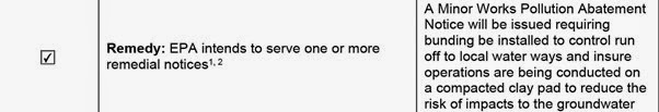
But the heavy metal-laden water can be, and has already
been, readily sprayed – in accordance with a facilitating work plan – by the
mine’s contractors around Lots 1 and 2, prior
to clay conditioning and the compacting of the surface, apparently
without the toxic water posing any “risk of impacts to the groundwater” worth
mentioning in the Environmental Auditor’s Report.

How much of this toxic water has already been employed for “dust suppression” and “clay conditioning” at Lot 2? How much of this heavy metal-laden water has already leached into the groundwaters? How much of this hazardous waste water has already reached the basement aquifer? How far has any plume extended already under and from the construction site?
Fortunately, one would have thought, there are provisions in the Auditor’s Report to find these things out. Through the medium of “baseline datasets”.
From page 3 of the Auditor’s Independent Review:
1.3 Independent Review Scope
[…]
2. To assess the proposed monitoring program
in line with Condition 7b of the Planning Permit, in order to assess whether:
-
Baseline surface water and groundwater
monitoring data is sufficient to assess impacts in the future;
-
The
locations and specifications of groundwater monitoring bores is sufficient;
-
The
surface water quality monitoring program is sufficient, including monitoring of
the larger farm dam on the opposite side of the South Costerfield-Graytown
Road;
-
The
monitoring program is sufficient for each period, including pre-construction
(i.e. baseline), construction and operation.
Except that no one bothered to sample from the “larger farm
dam” during the “pre-construction” period. And it’s still to happen.
The Auditor has no baseline dataset.
Appendix E of the Auditor’s Report begins with a to-ing and fro-ing of Comments and Responses between the Auditor and Mandalay on Baseline Datasets. The exchange listed as number 4 reads as follows:
The Auditor has no baseline dataset.
Appendix E of the Auditor’s Report begins with a to-ing and fro-ing of Comments and Responses between the Auditor and Mandalay on Baseline Datasets. The exchange listed as number 4 reads as follows:
Auditor’s Comment/Query: No
baseline data has been provided for the domestic rainwater tanks or the farm
dams. It is noted that an adequate pre-construction baseline dataset is
required in order to test for impacts in the future. Can Mandalay confirm
whether this testing has been undertaken and if so please provide the data?
Mandalay Resources Response: No
baseline farm dam or rainwater data has been collected. Will commence prior to
construction, as soon as practical.
Auditor’s Response and Recommendations: It is recommended that all surface water sampling from farm dams and
rainwater tanks on neighbouring properties are collected prior to any
construction works commencing.
Mandalay Resources Response: Agreed,
initial sampling to be completed prior to the commencement of construction
activities.
The final response from Mandalay was apparently received by
the Auditor on 17 October, 2014 (and was then incorporated into a document
dated 15 October, 2014…) and the Auditor’s Report was released on 24 October,
2014. As we’ve shown here, the approach from Mr Mattiske to Mr Colin Leask and
Ms Pamela King for sampling of the dam at 490 South Costerfield-Graytown Road
came on 22 October, the same
day that we reported that unannounced dust generating works had already commenced on Lot 1 in the
form of the construction of a road and workpad. This despite the fact that Lot1 is Subject Land (it had failed to appear on the Planning Permit; someone
having presumably forgotten to cut and paste it in… Mr Kilian? Ms Mansfield?).
By 28 October, 2014, four days after the Report was tabled, work was underway on Lot 2 and the dust was flying all over the area – beyond the dust deposition gauges that only measure dust deposition on Lot 2! – and so all chance of achieving the “baseline dataset… required” had been lost. Any pretense at precautionary measures was simply blown away.
From page iv of the Auditor’s Report comes this: “I hereby state that I am of the opinion that such work, if properly constructed and carried out in accordance with approved plans and specifications will meet the requirements of Condition 7 of the permit, subject to the following conditions:
Monitoring
·
All
surface water sampling locations from farm dams and rainwater tanks on
neighbouring properties are collected prior to any works commencing.
·
An
additional water sampling location is included from the drainage culvert
located at South Costerfield-Graytown Road.]
These are “conditions” upon which the “requirements of
Condition 7” rest in the opinion of the Auditor. One would therefore feel justified
in assuming that without these conditions
being met, the Auditor would be “of the opinion” that the “requirements” of Condition 7 of the
Planning Permit have not been met either.
And here is a picture of contaminated water flowing from the drainage culvert flowing onto 490 South Costerfield-Graytown Road after the late November rains. Straight in to the "large farm dam" that is, according to the Auditor, "likely to act as a recharge source [for the groundwater] rather than a discharge zone". That line of trees in the background is the Wappentake Creek.
And here is a picture of contaminated water flowing from the drainage culvert flowing onto 490 South Costerfield-Graytown Road after the late November rains. Straight in to the "large farm dam" that is, according to the Auditor, "likely to act as a recharge source [for the groundwater] rather than a discharge zone". That line of trees in the background is the Wappentake Creek.

- It took over three months for Bendigo Council to eventually release to Costerfield residents the results of geotechnical and Emerson dispersive testing.
- These “results” were gleaned from three geotechnical sample tests and a single sample for Emerson dispersive testing.
- Dozens of test pits dot the site but no results were provided to Bendigo council from these pits.
- SKM had previously concluded – by assessing results from 17 test pits – that the site’s clays and soils have “an average permeability of <1 x 10⁻⁸ m/s” and so with “good control… a permeability of 1 x 10⁻⁸ m/s is achievable”.
- A geotechnical report produced for the mine concluded that the "laboratory testing tends to indicate that he clays are generally suitable" for achieving 1 x 10⁻⁸ m/s, there were issues with the "methodologies of the testing... and especially with the permeability tests".
- VCAT imposed permeability of 1 x 10⁻⁹ m/s.
- No design specifications in the Design Report address the actual evaporation of water from this so-called “evaporation facility”; the facility was/is designed for water “storage” and employed DPI (2004) permeability specifications prior to objections to VCAT by residents.
- EPA guidelines referred to by the Auditor stress the “heterogeneous” nature of aquifers over short distances and thus the “critical” need for assessment of groundwater flow. The importance of assessing flow between aquifers – laterally and vertically – is emphasised. The interactions of “groundwater… with the land surface and with surface water” is described as “neglected” in many hydrogeological assessments.
- SKM regard URS’s assessment of “unlikely” vertical interaction to be “uncertain at the site” and suggest a bore.
- The Environmental Auditor notes these “data gaps” with respect to “vertical interactions” but dismisses the need for a bore to do this until pollution has already occurred.
- The Environmental Auditor compounds uncertainty by presenting obviously unexamined conditions as having “likely, likely, likely” effects on only the “closest potential environmental receptors” and ignoring any reference to the Wappentake Creek into which Splitters Creek runs.
- The geotechnical review notes disparities in the soils and clays between the north-west and south east corners of Lot 2; only a sample from the north-east was subjected to Emerson dispersive testing.
- The geotechnical review notes the proximities of the terminal dam to the underlying groundwater: "only 0.4m above the groundwater level".
- EPA Officers require a chemical-free farmer to compact a clay base for his organic compost to “reduce the risk of impacts to the groundwater”, but seem unperturbed by the spraying of toxic heavy metal laden, hazardous waste mine water onto the soils and clays of Lots 1 & 2 for dust suppression and clay conditioning prior to their compaction.
- The EPA-Appointed Environmental Auditor considers a “baseline dataset” of rainwater tank and dam sampling – prior to construction commencing – to be a determinant as to whether or not Planning Permit Condition 7 has been met.
- No baseline sampling has been conducted on adjacent properties.
- The EPA-Appointed Environmental Auditor requires sampling and monitoring of the culvert that runs into the property over the road from Lot 2.
And all of the above deals only with the contamination of
the groundwaters and surface waters. There’s still the matter of this water evaporating, taking with it toxic
compounds as vapour and leaving behind a load of toxic materials which are then
blown about Costerfield as dust.
The below is sourced from a report into the Air Quality Assessment of the Proposed Minewater Evaporation Facility prepared for Gadens Lawyers by Dr J. T. Bellair. It should be remembered that the comments regarding air quality are for the most part concerned with the emission of dust or airborne particles from the completed evaporation facility. Even when the construction phase if referred to there appears to have been no consideration given to the use of mine water for spraying as a "clay conditioner" and its subsequent possible drying and blowing about as dust. The dust referred to is merely the dust in the construction site soils.
Here is Dr Bellair's "complete" understanding of Air Quality Management with regards to toxic metals:


We are very concerned in Costerfield with the discharge of mine water containing soluble inorganic arsenic onto the soils, where it will a) leach through to the ground and surface waters, and b) dry our and blow about the countryside and into water tanks and people's mouths. This may not be known as a "point" emission for the purposes of the Schedule, but the National Pollutant Inventory would certainly deem it to be a "fugitive" emission.
Still, Dr Bellair is not concerned. And why not?

This is either a very dangerous error on the part of Dr Bellair or it is a very dangerous lie. He is the Air Quality expert and this is an uncorrected piece of documentation.
Here's the World Health Organisation on the subject of soluble inorganic arsenic. Take careful note of the very first sentence:
 Sorry, but we believe the WHO. And we have concerns about its presence in our drinking water. With good cause it would seem, despite Dr Bellair.

The Human and Environmental Rights Institute confirms our concerns:

Arsenic ranks at number 1 on the US Agency for Toxic Substances and Diseases (ATSDR) Priority List of Toxic Substances.
Again, inorganic arsenic in this toxic mine water is currently being used to "suppress dust" on Lot 2 and to "condition clay". It is being poured onto the soils and into the surface and groundwaters of Lot2 in Costerfield. And it is drying out and blowing about Costerfield and no one is giving a damn because - in part we assume - Dr Bellair and other facilitators of this mine are trying to convince everyone of the "fact that arsenic is not acutely toxic"!
That it's "just mine water".
And we get 100 km/h winds in Costerfield.
[We must admit that Dr Bellair's 1997 advice on Avoiding Potentially Dusty Operations During Summer Months is a decidedly good idea. He says: "Where possible preparatory activities, including surface stripping of overburden and construction of perimeter bunds, should be conducted outside the summer months."
That would be a considerate thing for the regulators of a mine to do for the quiet rural community upon which they have allowed a mine to impose itself.]
Below is a summary of the US Agency for Toxic Substances and Disease Registry (ATSDR) guidelines for toxicity of metals (and their toxic rankings) in the air side-by-side with the VicEPA’s guidelines for the same materials. The levels of these metals in the Costerfield soils is also provided.
To date, no testing or sampling of the air quality in Costerfield to assess these levels has been performed. No results are available to confirm that even the most basic testing to discover what forms of arsenic – let alone any other metals - are in the terraces of Lot 2, have been conducted.
And as for the additivity/synergistic testing and results that the Costerfield community was assured, by the Chief Inspector of Mines would be provided for their own properties… well, they are still to be provided.
(What’s a mining bureaucrat doing organising a health issue anyway?)
The below is sourced from a report into the Air Quality Assessment of the Proposed Minewater Evaporation Facility prepared for Gadens Lawyers by Dr J. T. Bellair. It should be remembered that the comments regarding air quality are for the most part concerned with the emission of dust or airborne particles from the completed evaporation facility. Even when the construction phase if referred to there appears to have been no consideration given to the use of mine water for spraying as a "clay conditioner" and its subsequent possible drying and blowing about as dust. The dust referred to is merely the dust in the construction site soils.
Here is Dr Bellair's "complete" understanding of Air Quality Management with regards to toxic metals:
We are very concerned in Costerfield with the discharge of mine water containing soluble inorganic arsenic onto the soils, where it will a) leach through to the ground and surface waters, and b) dry our and blow about the countryside and into water tanks and people's mouths. This may not be known as a "point" emission for the purposes of the Schedule, but the National Pollutant Inventory would certainly deem it to be a "fugitive" emission.
Still, Dr Bellair is not concerned. And why not?
This is either a very dangerous error on the part of Dr Bellair or it is a very dangerous lie. He is the Air Quality expert and this is an uncorrected piece of documentation.
Here's the World Health Organisation on the subject of soluble inorganic arsenic. Take careful note of the very first sentence:
The Human and Environmental Rights Institute confirms our concerns:
Arsenic ranks at number 1 on the US Agency for Toxic Substances and Diseases (ATSDR) Priority List of Toxic Substances.
Again, inorganic arsenic in this toxic mine water is currently being used to "suppress dust" on Lot 2 and to "condition clay". It is being poured onto the soils and into the surface and groundwaters of Lot2 in Costerfield. And it is drying out and blowing about Costerfield and no one is giving a damn because - in part we assume - Dr Bellair and other facilitators of this mine are trying to convince everyone of the "fact that arsenic is not acutely toxic"!
That it's "just mine water".
And we get 100 km/h winds in Costerfield.
[We must admit that Dr Bellair's 1997 advice on Avoiding Potentially Dusty Operations During Summer Months is a decidedly good idea. He says: "Where possible preparatory activities, including surface stripping of overburden and construction of perimeter bunds, should be conducted outside the summer months."
That would be a considerate thing for the regulators of a mine to do for the quiet rural community upon which they have allowed a mine to impose itself.]
Below is a summary of the US Agency for Toxic Substances and Disease Registry (ATSDR) guidelines for toxicity of metals (and their toxic rankings) in the air side-by-side with the VicEPA’s guidelines for the same materials. The levels of these metals in the Costerfield soils is also provided.
To date, no testing or sampling of the air quality in Costerfield to assess these levels has been performed. No results are available to confirm that even the most basic testing to discover what forms of arsenic – let alone any other metals - are in the terraces of Lot 2, have been conducted.
And as for the additivity/synergistic testing and results that the Costerfield community was assured, by the Chief Inspector of Mines would be provided for their own properties… well, they are still to be provided.
(What’s a mining bureaucrat doing organising a health issue anyway?)

And there are no
dust gauges anywhere in Costerfield except on the Subject Land. And the
wind blows and the dust flies all around Costerfield. Just ask Dr Bellair, who said in his 1997 (yes, 1997, he's been facilitating mining in Costerfield for a while) Independent Dust Assessment of the Open Cut mine in Costerfield that "most areas of Victoria are relatively dusty places. My visit to Costerfield on 3 April 1997 confirmed that the local area is no exception. As I slowly drove along the local unsealed roads, my vehicle raised a distinct cloud of dust."
In 1997 Dr Bellair concluded and recommended that:
Having reviewed the nature of the existing and proposed operations and available dustfall data, and considered the relevant buffer distances and available control measures, I do not expect that dust emissions from the project should cause any significant off-site amenity reduction or other problems (in respect of either dustfall or arsenic in rainwater).
And wasn't 1998 a grand year in Costerfield dust history?
And there is still a Victorian Government investigation into contaminated soils and water tanks in Costerfield underway. Citizens have to organise their own testing.
And all day the toxic water is being dumped, ahem, discharged, ahem, used for "clay conditioning" and "dust suppression", and flows towards the “closest environmental receptors”, and dries and blows around the district as dust.
And this is being done purely and solely to facilitate the mine in disposing of its dewatering allowance that has been over-allotted by the regulators.
What is going on here?
Where is the Environment Protection Authority?
When is someone going to give Mr Finegan that GPS-equipped car?
When is someone going to take control and begin doing what needs to be done?
This is all supposed to have been done already. Arsenic is a Class 3 Indicator.
No comments:
Post a Comment
Be civilised and rational... rants and abuse will be moderated out of existence.